AMAR BHUBAN: Milan's World

Bangladesh

Home
About Me
My Resume
Family Photo Album
Photo Album
Sweet Memories
Bangladesh
Japan
My Diary
External Links
Contact Me
picture1.gif
National Flag

Selection of Natural Wonders:
 
bd.jpg
Please click the above picture to have the Map of Bangladesh Edit Picture

Entertainment 
ET CETERA
Bangla Resources

Jamuna Multipurpose Bridge: World's 12th Longest
jamunabridge.jpg
Please click the above photo to have a look of the Bridge

My Beautiful Bangladesh:

 ***  Bangladesh Photo Gallery

 
----------------------------------------------------

COUNTRY PROFILE
Name
Capital
Currency
Taka (BDT)
Language
Bangla or Bengali (Official), English (Widely used)
Government Type
Parliamentary Democracy (Unitary Form)
Time Zone
GMT+ 6
National Day
March 26 (Diclaration of Independence)
Victory Day
December 16. Please click here to see a Video on Victory.
International Mothor Language Day
February 21 (Ekushe February). Please click here to see Video on Aumar Ekushe.
Festivals
Pohela Baishakh (Bangla New Year, April 14), Boat_Race, Fairs, Religious (EIDs, Pujas, Xmas, Buddhists_Purnima) etc.
Boundary
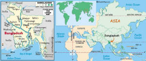
Surrounded by India on all sides except for a small border with Myanmar to the far southeast and the Bay of Bengal to the south. Please click here to see the geographical location of Bangladesh
Territorial Water
12 Nautical Miles
Landscape
Mostly Alluvial Flat Low Land; Hilly in the Southeast Part
Tourist's Spots
Cox's Bazar: World's Longest Seabeach, Sundarban: World's Heritage, Saint Martin, Kowakata, Tea Garden (Sylhet), Paharpur (Naogaon), Mohastangarh (Bogra), Sonargaon (Dhaka), Madhobkunda etc.


Your visiting serial:

-------------------------------------------------------------------
 
All Rights Reserved by Saidur Rahman Milan